

You can find on this page the Malta geographical map to print and to download in PDF. The Malta geographic map presents the topography, elevation, rivers, mountains, climate and physical features of Malta in Southern Europe.
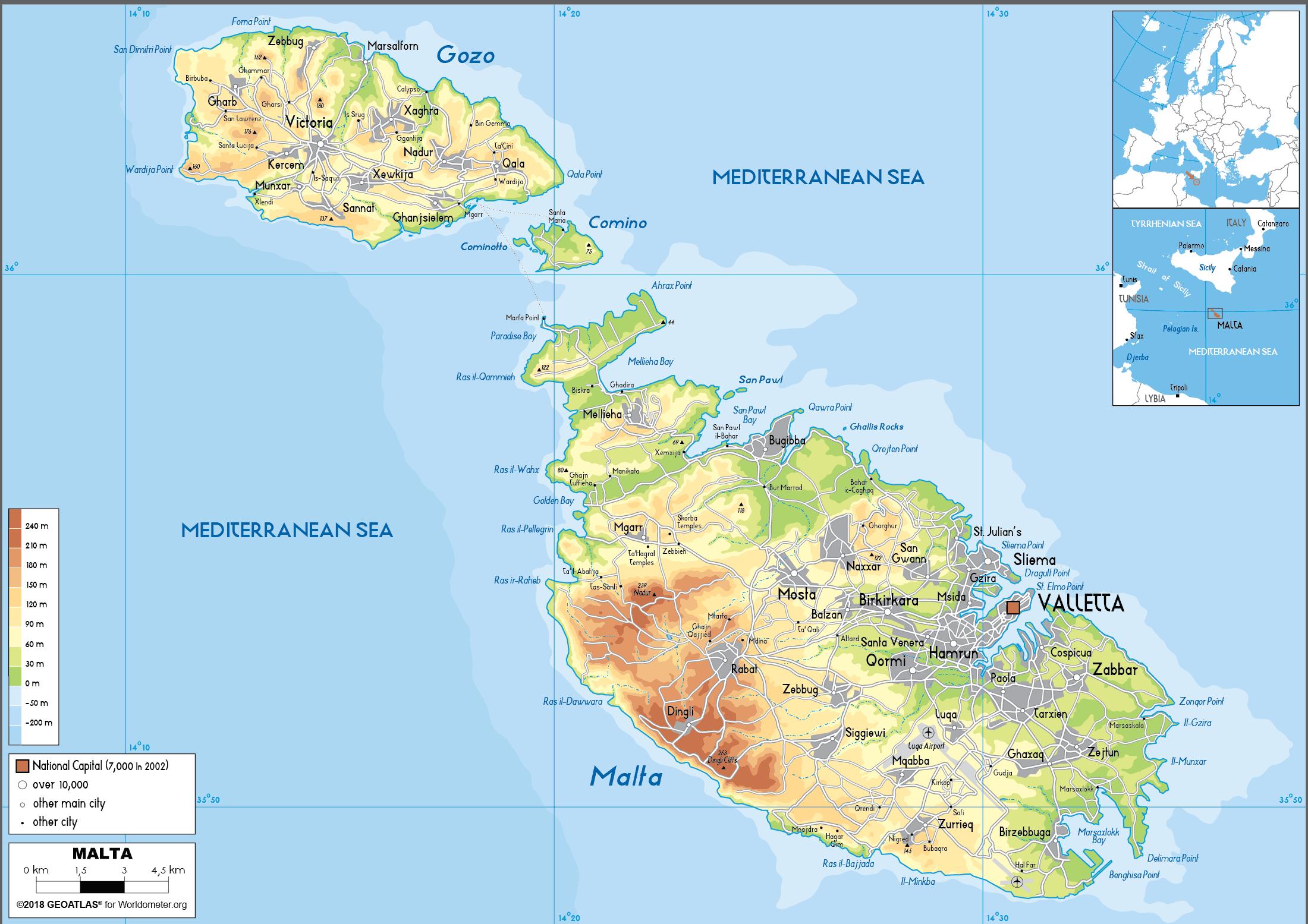
The Malta physical map shows landform and geography of Malta. This geographical map of Malta will allow you to discover physical features of Malta in Southern Europe. The Malta physical map is downloadable in PDF, printable and free.
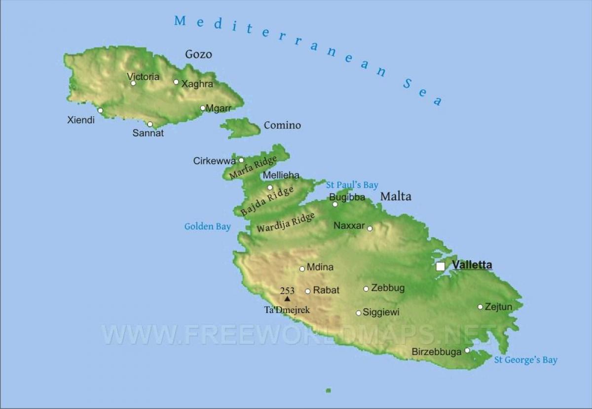
As observed on Malta physical map, the country comprises five islands—Malta (the largest), Gozo, Comino, and the uninhabited islets of Kemmunett (Comminotto) and Filfla—lying some 58 miles (93 km) south of Sicily, 180 miles (290 km) north of Libya, and about 180 miles (290 km) east of Tunisia, at the eastern end of the constricted portion of the Mediterranean Sea separating Italy from the African coast. In northern Malta the escarpment is occasionally abrupt and broken by deep embayments. To the south, however, the plateau gradually descends from about 600 to 830 feet (180 to 250 metres) into undulating areas of globigerina (derived from marine protozoa) limestone less than 300 feet (90 metres) in elevation. The western area is characterized by deeply incised valleys and undercliff areas, while to the east there are several valley systems that descend to the central plains.
The main physical characteristic of the island of Malta is a well-defined escarpment that bisects it along the Victoria Lines Fault running along the whole breadth of the island from Point ir-Raħeb near Fomm ir-Riħ Bay to the coast northeast of Għargħur at Madliena Fort as its shown in Malta physical map. The highest areas are coralline limestone uplands that constitute a triangular plateau; Ta’ Żuta, which rises to 830 feet (253 metres) in the southwest, is the highest point. The uplands are separated from the surrounding areas by blue clay slopes, while an undercliff area is found where the coralline plateau has fallen and forms a subordinate surface between the sea and the original shore. The total shoreline of Malta is about 136 miles (219 km).
The west coast of Malta presents a high, bold, and generally harbourless face. On the east, however, a tongue of high ground known as Mount Sceberras, on which the capital city, Valletta, is built, separates Marsamxett Harbour and Grand Harbour. Because of tectonic activity, Malta has been tilted in a northerly direction, producing cliffs of up to about 800 feet (250 metres) high on the south and southwestern coasts, while slopes descend to low cliffs and rocky shores on the northern and eastern coasts as you can see in Malta physical map.
Malta topographic map shows the physical features of Malta. This topographical map of Malta will allow you to discover landforms and geographical of Malta in Southern Europe. The Malta topographic map is downloadable in PDF, printable and free.
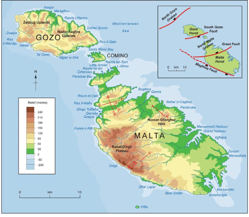
The islands of Malta are dominated by limestone formations, and much of their coastlines consist of steep or vertical limestone cliffs indented by bays, inlets, and coves. They lie on the submerged Malta-Hyblean Platform, a wide undersea shelf bridge that connects the Ragusa Platform of southern Sicily with the Tripolitana Platform of southern Libya. The landscape of the island of Gozo is characterized by broken upper coralline mesas, with the highest point being Ta’ Dbiegi Hill (636 feet [194 metres]) as its shown in Malta topographic map. Gozo has a gentle easterly dip, so the lower coralline limestone, which forms high cliffs on the west coast, declines to below sea level but reappears on the east coast at Qala Point. Semicircular bays have formed on coastal cliffs where sinkholes have been invaded by the sea. The rounded bays at Xlendi and Dwejra on the west coast of Gozo originated as underground caverns with roofs that have collapsed.
The island of Malta possesses favourable conditions for the percolation and underground storage of water as its mentioned in Malta topographic map. The impermeable blue clays provide two distinct water tables between the limestone formations—the perched and the mean sea-level aquifer. The principal source for the public supply of water has for several centuries been the main sea-level water table. The absence of permanent streams or lakes and a considerable runoff into the sea, however, have made water supply a problem, which has been addressed with an intensive reverse-osmosis desalination program. About half of Malta daily water needs are supplied by desalination plants throughout the islands.
Mainly young or immature and thin, Maltese soils generally lack humus, and a high carbonate content gives them alkaline properties. Human settlement and construction developments have altered the distribution and composition of soils. The Fertile Soil (Preservation) Act of 1973 requires that, when soils are removed from construction sites, they be taken to agricultural areas, and level stretches in quarries are often covered with carted soil. Malta flora and fauna are typical of the low-lying coastal regions of the Mediterranean as you can see in Malta topographic map. Excessive exploitation of the forests for timber and the clearance of land for construction and agriculture have destroyed much of Malta woodlands, though a few stands of holm oak remain. Aleppo pine has been successfully reintroduced.

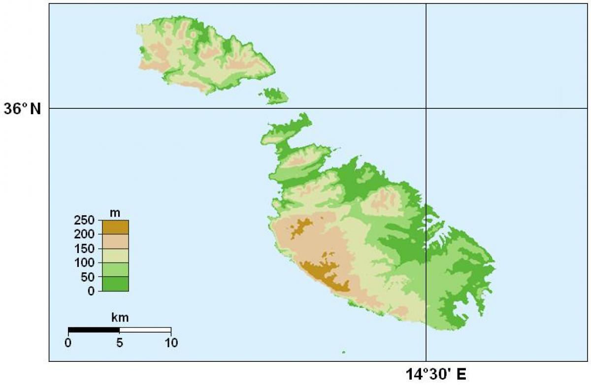
The Malta elevation map shows the different altitudes of Malta. This altitude map of Malta will allow you to know where are the highest and lowest regions of Malta in Southern Europe. The Malta elevation map is downloadable in PDF, printable and free.
Malta extreme elevation points as you can see in Malta elevation map: Northernmost point – Reqqa Point, Gozo 36°4′55″N 14°14′9″E. Northernmost settlement – Żebbuġ, Gozo 36°4′15″N 14°14′13″E. Southernmost point – Filfla 35°47′N 14°24′E. Southernmost settlement – Birżebbuġa, Malta 35°49′32″N 14°31′41″E. Westernmost point – San Dimitri Point, Gozo. Westernmost Settlement – Saint Lawrence, Gozo 36°3′18″N 14°12′15″E. Easternmost Point – Xrobb il-Għaġin, Malta 35°50′26″N 14°34′11″E. Easternmost Settlement – Marsaskala, Malta 35°51′45″N 14°34′3″E.
At 253 m, Ta'Dmejrek is the highpoint of the Republic of Malta as its shown in Malta elevation map. Located on the main island of the country, also called Malta, it is not a mountain; I would not even call it a hill. It is just a small plateau, most of which is occupied by a quarry for building materials - which implies that what is the highest point right now might one day be dug up to sell the sand or limestone below it. The quarry is easily recognizable on Satellite View. Ta'Dmejrek is an underwhelming place to visit. The quarry does not help with the scenery, and, being a plateau, the summit views are not what you might expect from the highest point of a small island. However, as if to make up for that, immediately south of the plateau lies a dramatic coastline with the sheer Dingli Cliffs, a great site and perhaps the best place to watch the sunset, at least in winter. The highest point is just a few meters north of the coastal road, Triq Panoramika - the name says it all.
Malta is a small island. The high point is 12 km from the airport and 13 km from the Grand Harbour ferry terminal so it is quite feasible to walk, but for the most part the scenery is not worth it. The nearest bus stop (visible in Satellite view) is called Zuta, on Triq Panoramika, half a kilometer east of the actual highpoint (and almost the same elevation) as its mentioned in Malta elevation map. According to Malta Public Transport it is serviced by bus 201 connecting the airport with Ir-Rabat and passing through Ħad-Dingli, the nearest town. There is (free) parking space along the road, to accommodate visitors for the Dingli Cliffs. Few tourists come in winter, the low season, which means that there is plenty of room to park, and rental cars are cheap. If you are in a hurry and your only goal is to visit the country highpoint, you do not need accommodation: the quickest way is to fly in and out on the same day and take a taxi from the airport. Without traffic it is a 15 minute drive (one way). The drive is mostly in the countryside so even with some traffic it should not take all that much longer.
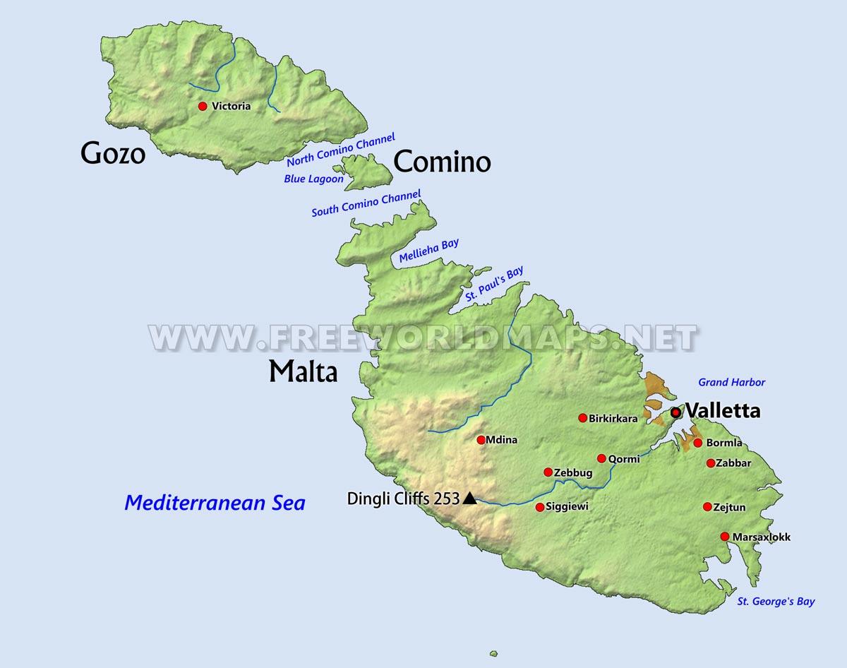
The rivers in Malta map shows the principal rivers with their names of Malta. The rivers map of Malta will allow you to find the main rivers which flow in and through Malta in Southern Europe. The Malta rivers map is downloadable in PDF, printable and free.
The largest island in the Republic of Malta archipelago, the island of Malta spans some 27 kilometers (17 miles) from northwest to southeast as you can see in Malta rivers map. The island sits in the Mediterranean Sea, south of Sicily. Graced with numerous bays serving as natural harbors, Malta may originally have been reached by raft 7,000 years ago, and it has been inhabited ever since. Malta is not only one of Europe smallest countries, but also one of its most densely populated. The porous limestone and the permeable greensand strata in the Maltese Islands allows rainwater to percolate through rock fissures to the impermeable clay strata. Perched water tables can be found at Pwales, Marfa and Comino.
The Pliocene (5.333 million years ago - 2.58 million years ago) and early Pleistocene (2,580,000 to 11,700 years ago) were marked by the Pluvial periods coinciding with the Ice Age. River tributaries coming from the north, when Malta was still attached to the continent, have eroded land to create valleys such as Wied il-Ghasel (Mosta), Wied il-Kbir (Qormi) and Wied Dalam (Birzebbuga) in Malta and Wied il-Ghasri (Iz-Zebbug) in Gozo as its shown in Malta rivers map. These present different characteristics to, say, Mgarr ix-Xini valley (Wied Hanzira) in Gozo which was formed due to fault lines.
There are no permanent rivers on the islands but heavy rainfall continues to contribute to the erosion of the valleys as its mentioned in Malta rivers map. In addition, as waterlogged soil causes water carrying clay, soil and sand to run towards the sea, a delta may form by the precipitating coarser materials as the stream meets the sea. When clay becomes waterlogged, its viscosity causes landslipping, fracturing the overlying greensand and upper coralline limestone and causing it to slide; meanwhile, running water forms the characteristic grooves in the clay slopes.

The mountains in Malta map shows the principal mountains with their names in Malta. The mountains map of Malta will allow you to find the main mountains ranges and highest mountains of Malta in Southern Europe. The Malta mountains map is downloadable in PDF, printable and free.
Although the Maltese Islands may lack certain features such as mountains, rivers and forests which prevail in other countries, topographically speaking, the islands have much to offer. Sheer cliffs made of layer upon layer of sedimentary rock rise sharply from the water, especially on the western side of both Malta and Gozo as you can see in Malta mountains map. The latter is characterised by flat-topped hills and lush green valleys, which are covered in multi-coloured wild flowers in spring before turning golden brown in the hot summer months. While it showcases some great architecture and natural sights, you wont find a single forest in Malta. There are also no mountains or rivers across all seven islands.
Hikes in Malta place you amongst the beauty of its three islands. Malta island itself is home to quaint fishing villages, terraced farms, crystal-clear seas and secretive valleys as its shown in Malta mountains map. Experience incredible limestone cliff scenery and inspirational sunsets on a coastline that is in equal parts spectacular and dynamic. Malta Valley also called the Valley of Tumbling Waters with its rivers, streams and thundering waterfalls, stretches from the "ARTIST TOWN of Gmünd" via the mountaineering village of Malta all the way up the Malta high alpine road to the Kölnbrein-dam. With the mountaineering village of Mallnitz, the municipality of Malta shares the two highest mountains of the Ankogel group, the eponymous Ankogel and the Hochalmspitze.
Malta shares with the Mountaineering Village of Mallnitz the two highest mountains in the Ankogel group, namely the Ankogel and the Hochalmspitze. On account of its symmetrical shape and beauty, the latter is often reverently described as the Queen of the Tauern mountains. Height above sea level of Malta: 843m and its highest point: 3,360 m (Hochalmspitze) as its mentioned in Malta mountains map. Mdina to Manikata, experience this 15.4-km point-to-point trail near Rabat, Rabat. Generally considered a moderately challenging route, it takes an average of 3 h 56 min to complete. This trail is great for hiking, mountain biking, and trail running. The trail is open year-round and is beautiful to visit anytime. Dogs are welcome, but must be on a leash.